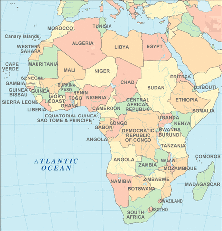
Countries and Territories of Africa
Places to Visit in Africa
- Algeria
- Angola
- Bassas da India
- Benin
- Botswana
- British Indian Ocean Territory
- Burkina Faso
- Burundi
- Cameroon
- Cape Verde
- Central African Republic
- Chad
- Comoros
- Democratic Republic of the Congo
- Djibouti
- Equatorial Guinea
- Eritrea
- Ethiopia
- Europa Island
- Gabon
- Ghana
- Glorioso Islands
- Guinea
- Guinea-Bissau
- Heard and McDonald Islands
- Juan de Nova Island
- Kenya
- Lesotho
- Liberia
- Libya
- Madagascar
- Malawi
- Mali
- Mauritania
- Mauritania
- Mauritius
- Mayotte
- Merzouga
- Morocco
- Mozambique
- Namibia
- Niger
- Nigeria
- Province of Sahara
- Republic of Côte d'Ivoire
- Republic of the Congo
- Reunion
- Rwanda
- Saint Helena
- Sao Tome and Principe
- Senegal
- Seychelles
- Sierra Leone
- Somalia
- South Africa
- South Sudan
- Sudan
- Swaziland
- Tanzania
- The Gambia
- Togo
- Tristan da Cunha Island group
- Tromelin Island
- Tunisia
- Uganda
- Zambia
- Zimbabwe
Cheap Hotels In Africa
http://www.airbnb.com/search?location=South+Africa
http://www.lastminute.com/hotels-d1-africa-hotels
http://southafrica.bedandbreakfasts.net/
http://www.africansunhotels.com/
http://www.hotelscombined.com/City/Johannesburg.htm
http://www.hotelinsouthafrica.net/
http://www.sleeping-out.co.za/
http://www.airbnb.com/search?location=South+Africa
http://www.lastminute.com/hotels-d1-africa-hotels
http://southafrica.bedandbreakfasts.net/
http://www.africansunhotels.com/
http://www.hotelscombined.com/City/Johannesburg.htm
http://www.hotelinsouthafrica.net/
http://www.sleeping-out.co.za/
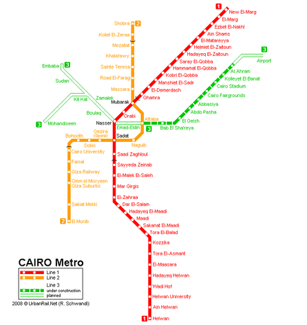
Cairo Metro Map ( Save for Zoom )
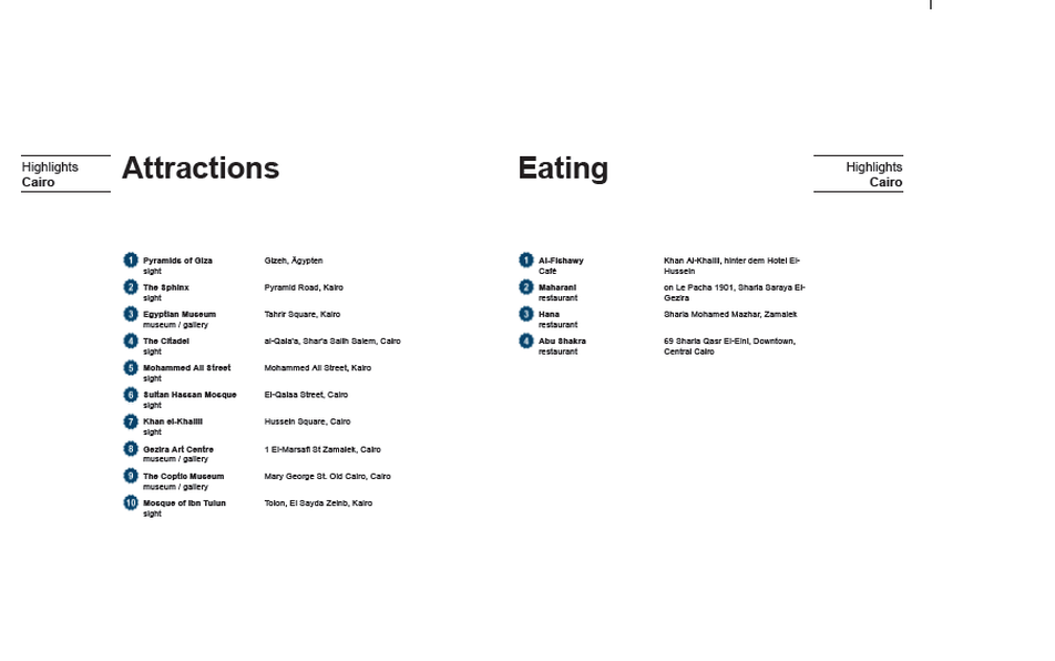
Top Things To Do

Custom Search
THE PYRAMIDS OF EGYPT ( Cairo )
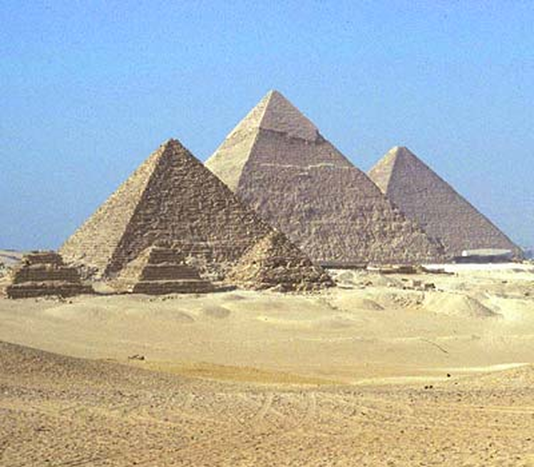
One of the first things that visitors to the Pyramids will notice is their unexpected proximity to Cairo. The second is the onslaught of hustlers that bombard the awe-struck onlooker. Despite the increased police presence that tries in earnest to subdue the camel and horse hustlers, water and soda hawkers and papyrus and postcard vendors, they still get through. Be firm with your ‘no’ and they’ll get the point, eventually. To get the best out of the experience, it’s definitely recommended to be first through the gate or the last person in before the gates close, and strike off into the desert around to view their majesty from afar.
Of the Seven Wonders of the ancient world only the Pyramids are left standing. Those at Giza are by no means the only ones in Egypt but they are the largest, most imposing and best preserved. When Herodotus, chronicler of the Ancient Greeks, visited them in 450 BC they were already more ancient to him than the time of Christ is to us today. That the huge blocks were quarried, transported and put into place demonstrates how highly developed and ordered the Old Kingdom was at its peak. Herodotus claimed that it would have taken 100,000 slaves 30 years to have constructed the great Pyramid of Cheops, but it is more likely that the pyramid was built by peasants, paid in food, who were unable to work the land while the Nile flooded between July and November. Happily, the high waters also made it possible to transport the casing stone from Aswan and Tura virtually to the base of the pyramids. The enormous Pyramid of Cheops, built between 2589-2566 BC out of over 2,300,000 blocks of stone with an average weight of two and a half tonnes and a total weight of 6,000,000 tonnes to a height of almost 140 m, is the oldest and largest of the pyramids at Giza. Maybe not surprisingly, it can be seen from the moon. The Pyramid of Chephren and Pyramid of Menkaure date from 2570-30 BC. There is a theory that the odd plan of the three Pyramids of Giza, progressively smaller and with the third slightly offset to the left, correlates to the layout of the three stars of Orion’s Belt. Highly controversial, it suggests that the Ancient Egyptians chose to reproduce, on land and over a great distance, a kind of map of the stars.
A breakdown in the structure of society, and the reduction of wealth, have been proposed as reasons why other pyramids were not constructed on the same scale later in the Old Kingdom. The first thefts from tombs occurred relatively soon after the Pyramids’ construction, which was undoubtedly an important factor in the preference for hidden tombs, such as in The Valley of the Kings, by the time of the New Kingdom.
A camel ride around the pyramids can be a fun way to take in their splendour, offer no more than E£20 for a short ride – to be paid after your meander. AA and MG stables (past the entrance to the Sphinx) are among the more notable in Giza.)
See individual sight entries for The Great Pyramid of Cheops (Khufu), Pyramid of Chephren, The Sphinx, Pyramid of Menkaure (Mycerinus) and Subsidiary
There are no more famous ancient sites within Egypt, or for that matter elsewhere in the world, than the Great Pyramids at Giza. They are, without question, the icon most associated with the Egypt. They have been both the main destination for tourists, and a source of imaginative thought to the world for over three thousand years.
However, there are actually over 100 pyramids in Egypt, many of which are relatively unknown to anyone who is not an ancient Egypt enthusiast. All but a very few are grouped around and near the City of Cairo, just south of the Nile Delta. Otherwise, only one royal pyramid is known in southern Egypt (at Abydos), that being the one built by Ahmose, founder of the 18th Dynasty and Egypt's New Kingdom.It may have also been the last royal pyramid built in Egypt.
Hence, major pyramids were not built throughout Egypt's ancient history. The Pyramid Age began with a burst of building, starting with the 3rd Dynasty reign of Djoser. Some of the early kings, most specifically Snefru, built more than one pyramid. Almost all of the kings added to their number through the end of the Middle Kingdom, with the possible exception of the First Intermediate Periodbetween the Old and Middle Kingdoms. After the first Pharaoh of Egypt's New Kingdom, Ahmose, royal pyramid building by Egyptians ceased entirely. Somewhat abruptly the kings of the New Kingdom chose, rather than making their tombs completely obvious, to hide them in the hills of theWest Bank of Thebes (modern Luxor).
However, smaller pyramids were constructed, for example in the Deir el-Medina necropolis, by private individuals. The Late Period Nubians who ruled Egypt also built relatively small pyramids with much steeper sides, though these were in fact constructed in Nubia itself. This tradition was carried on in Nubia after these southern rulers lost control of Egypt, and eventually, more pyramids were actually built in Nubia than Egypt, though on a much smaller scale.
Other pyramids in the world certainly exist, but their purpose, for the most part, was different than those of ancient Egypt. The most famous outside Egypt are probably those located in Mexico and to the south of Mexico, but these appear to have been built more as temples. In Egypt, all but a select few of the pyramids were built as tombs, sometimes to hold the physical body of a pharaoh (as well as other individuals), or to hold the soul of the deceased (as in the case of the small cult pyramids built next to the larger ones). Otherwise, the purpose of only a few small, regional stepped pyramids remains elusive.
While pyramids were, for the most part, tombs for the Pharaohs of Egypt, one must nevertheless question the reason that Egyptian rulers chose this particular shape, and for that matter, why they built them so large. Today, we believe that they chose the shape in order to mimic the Benben, a pyramid shaped stone found in the earliest of temples, which itself is thought to symbolize the primeval mound from which the Egyptians believed life emerged. This also connected the pyramid to Re, the Sun God, as it was he, according to some of the ancient Egypt mythology, who rose from the primeval mound to create life.
As far the great size of many of the pyramids in Egypt, we can really only surmise that the Pharaohs were making a statement about their own power and perhaps, about the glory and strength of their country. However, it should also be remembered that many of the latter pyramids were not nearly as large as the Great Pyramids at Giza (and elsewhere).
Pyramids evolved. The first of them was not a perfectly formed pyramid. In fact, the first Pyramid we believe that was built in Egypt, that of Djoser, was not a true pyramid at all with smooth sides and a point at the top. Rather, its sides were stepped, and the top of the pyramid truncated with a flat surface (as best we know). As the Egyptian pyramids evolved, there were failures as well glorious failures until finally, they got it right with what was probably the first smooth sided true pyramid builtat Meidum. In fact, pyramids continued to evolve throughout their history, perhaps not always in outward appearances, but in the way that they were built and in the theology surrounding their construction. For example, towards the latter part of Egypt's Pyramid Age, Osirian beliefs seem to have had more and more impact on the arrangement and layout of the subterranean chambers.
However, soon after the first pyramids were built, their form became somewhat standardized. Royal pyramid complexes included the main pyramid, a courtyard surrounding the main pyramid, a much smaller cult pyramid for the king's soul, a mortuary temple situated next to the main pyramid, an enclosure wall and a causeway that led down to a valley temple. Some pyramid complexes included subsidiary, smaller pyramids for family members, and most were surrounded by some sort of tombs for family members.
Our thinking on pyramids has evolved considerably over the years. Many of us who are a bit older were taught that the pyramids were built using Jewish slave labor, which is a fabrication of immense proportions. Most of the pyramids were built long before the Jews made their appearance historically and currently, many if not most scholars believe they were not built using slave labor at all (or perhaps a nominal number of slaves).
Otherwise, we can also dismiss offhand alternative theories related to aliens or some lost culture being responsible for pyramid building. There is just far too much evidence, including tools, drawings, evolutionary changes, and even worker villages that rule these farfetched ideas obsolete.
However, some mysteries remain, even in some of the best well known Pyramids. The most famous of them all, the Great Pyramid of Khufu, continues, year after year, to give up a few more secrets, and there doubtless remains much to learn from these Egyptian treasures. There may even be one or more pyramids yet to be discovered.
NATIONAL PARK Table Mountain National Park
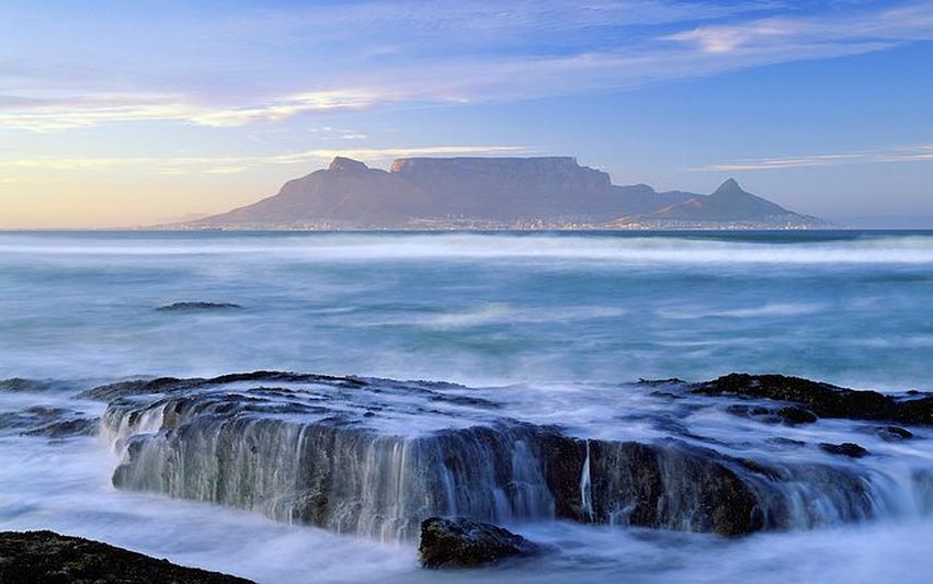
Cape Town is defined, first and foremost, by Table Mountain. Rising a sheer 1073 m from the coastal plain, it dominates almost every view of the city, its sharp slopes and level top making it one of the world’s best-known city backdrops. For centuries, it was the first sight of Cape Town afforded to seafarers, its looming presence visible for hundreds of kilometres. Certainly, its size continues to astonish visitors today, but it is the mountain’s wilderness, bang in the middle of a bustling conurbation, that makes the biggest impression. Table Mountain sustains over 1400 species of flora, as well as baboons, dassies (large rodents) and countless birds. The Table Mountain National Park encompasses the entire peninsula stretching from here to Cape Point. Between September and March you have the additional pleasure of seeing the mountain covered in wild flowers. The most common vegetation is fynbos, of which there is an extraordinary variety, but you’ll also see proteas plus the rare silver tree, Leucadendron argenteum.
The dizzying trip to the top in the Aerial Cableway is one of CapeTown’s highlights. The first cableway was built in 1929, and since then has had three upgrades, the latest being in 1997. It’s estimated to have carried up some 18 million people to date. There are two cars, each carrying up to 65 passengers, and as you ride up the floor rotates, allowing a full 360° view. Journey time is just under five minutes. In the base of each car is a water tank that can carry up to 4000 litres of freshwater to the top. There is theTable Mountain Café at the top station, which also has a deli for takeaway sandwiches, cheese and sushi platters and other light meals. To conserve water, they’ve recently introduced compostable plates and containers. An extensive network of paths has been laid out from the top station, allowing walks of various lengths, leading to different lookout points with stunning views of the City Bowl, Cape Flats, Robben Island and back along the peninsula. There are also free guided walks daily at 1000 and 1200.
The entire area is a nature reserve, and the mountain is protected as a national monument. There are numerous paths climbing to the top. The most popular route starts 1.5km beyond the Lower Cableway Station and follows a course up Platteklip Gorge; there’s another path from Kirstenbosch Botanical Gardens. Both take about two to three hours to the top, although they are both fairly tough and should not be taken lightly. Given Table Mountain’s size and location, conditions can change alarmingly quickly. The weather may seem clear and calm when you set out, but fog (the famous ‘TableCloth’ which flows from the top) and rain can descend without warning. Numerous people have been caught out and the mountain has claimed its fair share of lives. There have also been recent muggings in Platteklip Gorge, though authorities are presently doing their best to address the problem. Before venturing out, make sure you have suitable clothing, food and water. Take warm clothes, a windbreaker, a waterproof jacket, a hat, sunscreen, sunglasses, plenty of water (2 litres per person) and energy foods. Never climb alone and inform someone of which route you’re taking and what time you should be back. Also be aware that if the weather is too unfavourable for the cableway to be open, don’t rely on it being open to take you back down, so allow enough daylight hours to make the descent on foot. A detailed map is essential –these can be purchased at the tourist office. For those wanting to spend more time on the mountain, an100km overnight trail –the oerikwagga Trail (meaning ‘sea mountain’ in Khoi)–was introduced in 2005. The name means ‘mountains in the sea’ in an indigenous language. The six-day trek involves sleeping in tented camps and renovated forester houses dotted along the top of the mountain, and food and overnight gear is carried by porters. It starts in central Cape Town and ascends Platteklip Gorge and then follows the spine of the peninsula down to Cape Point. For full details, contact the tourist office or SANParks. If you’re interested in learning about the mountain’s flora and fauna, take a guide or a tour)

SIGHT Djemaa el Fna
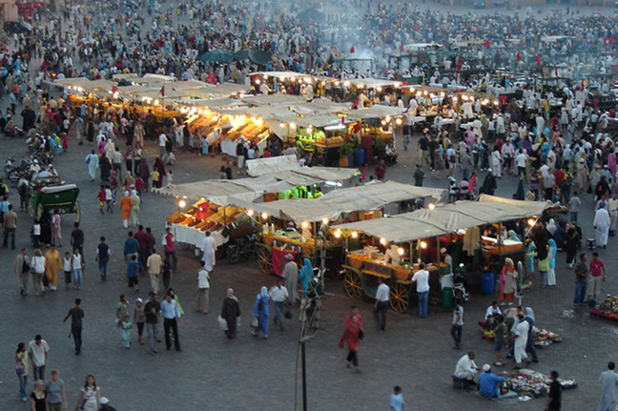
The market place in Marrakech is an experience for all senses
This square is the highlight of Morocco par excellence! The Djemaa el Fna (market place) has been protected by the Unesco as a master piece of oral and immaterial human heritage for years. It still draws hundreds, thousands of Moroccans from near and far, day after day and night after night, who listen to the storytellers who cheer on the fire-eaters and believe everything the healers say.
This square is the highlight of Morocco par excellence! The Djemaa el Fna (market place) has been protected by the Unesco as a master piece of oral and immaterial human heritage for years. It still draws hundreds, thousands of Moroccans from near and far, day after day and night after night, who listen to the storytellers who cheer on the fire-eaters and believe everything the healers say.
BEACH Clifton Beach
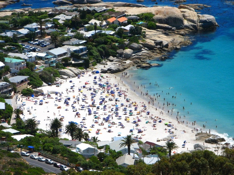
Cape Town’s best-known beaches stretch along Clifton, and are renowned as the play- ground of the young and wealthy – this is the place to see and be seen. Other than being hotpots of high society, Clifton’s four sheltered beaches are stunning, perfect arches of powder-soft white sand sloping gently into turquoise water. The beaches, reached be a series of winding footpaths, are divided by rocky outcrops and are unimaginatively named First, Second, Third and Fourth. Each has a distinct character – if you’re bronzed and beautiful, head to First beach. More demure visitors may feel more comfortable on Fourth, which is popular with families and has been an award-winning Blue Flag beach for many years now. The sunbathing and swimming are good on all the beaches and life guards are on duty, but note that the water is very cold – usually around 12°C. Most of the relatively small-scale, high-luxury development has been behind the beaches (some impressive houses can be glimpsed from the winding steps leading down). Be warned that there is limited parking in high season, so get here early.
NATIONAL PARK Kruger National Park
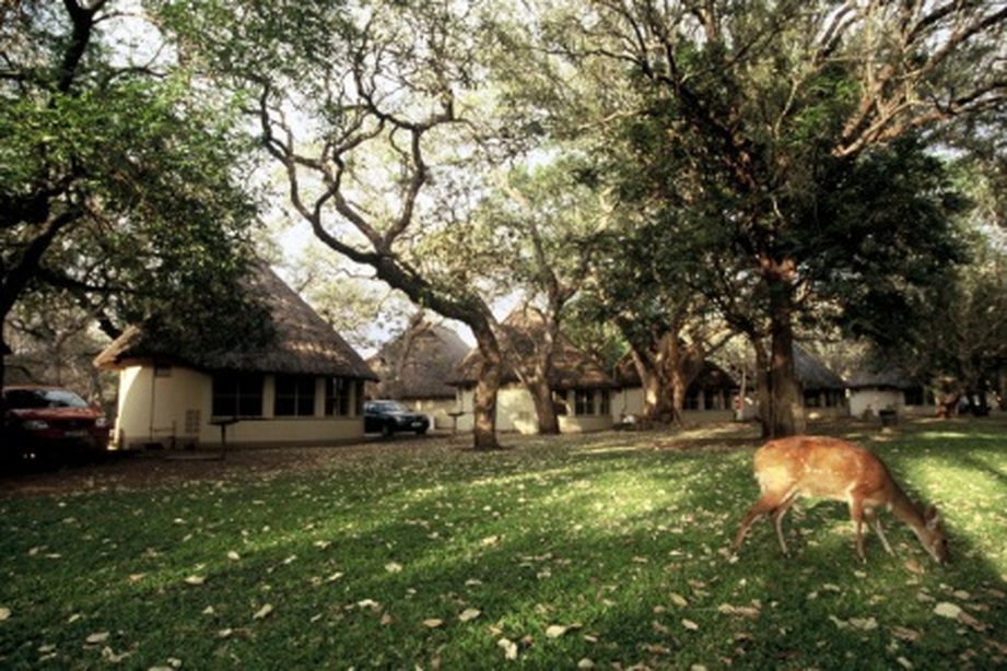
A wonderful variety of wildlife experiences which equal the best found anywhere in Africa
Kruger Park is the king of South African game parks and one of the best game-viewing areas in all of Africa. The figures speak for themselves: 507 bird species, 114 reptiles, 49 fish, 34 amphibians, 147 mammal and over 23,000 plant species have been recorded here. The region itself is enormous, extending from the Crocodile River in the south to the Limpopo in the north, from the wooded foothills of the eastern escarpment to the humid plains of the Lowveld. It certainly fulfils most visitors’ fantasies of seeing magnificent herds of game roaming across acacia-studded stretches of savannah and, of course, is home to the Big Five. The park is 60 km wide and over 350 km long, conserving 21,497 sq km, an area the size of Wales or Israel. Despite its size, it is very well developed, with a good network covering 2600 km of roads and numerous camps, making a Kruger safari relatively hassle free.
Don’t expect to have the park to yourself, however. Kruger receives over one million visitors a year and the park camps cater for up to 5000 visitors a day. Nevertheless, despite the huge number of people passing through, Kruger has managed to maintain its wild atmosphere. Only 5% of the park is affected by the activities of the visitors and only a few areas in the south come close to the overcrowding seen in East Africa’s game parks.
While much of the park is designed for self-driving and self-catering, it is possible to stay in an ever-expanding choice of top-end private reserves, which are popular with first-time visitors as all game drives are led by rangers, so you can leave the animal-spotting to the experts. The fences that once split Kruger from the private reserves have now come down, so game can roam freely between the park and private concessions.
NATIONAL PARK Ngorongoro Crater
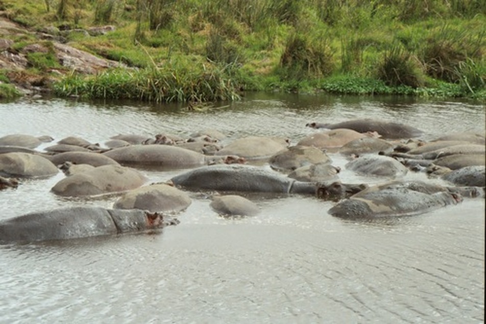
The Ngorongoro Conservation Area (NCA)
is a conservation area and a UNESCO World Heritage Site situated 180 km (112 miles) west of Arusha in the Crater Highlands area of Tanzania. The conservation area is administered by the Ngorongoro Conservation Area Authority, an arm of the Tanzanian government, and its boundaries follow the boundary of the Ngorongoro Division of Ngorongoro District. The Ngorongoro Crater, a large volcanic caldera, lies within the area.
is a conservation area and a UNESCO World Heritage Site situated 180 km (112 miles) west of Arusha in the Crater Highlands area of Tanzania. The conservation area is administered by the Ngorongoro Conservation Area Authority, an arm of the Tanzanian government, and its boundaries follow the boundary of the Ngorongoro Division of Ngorongoro District. The Ngorongoro Crater, a large volcanic caldera, lies within the area.
